Critical infrastructure—including transportation networks, energy systems, water treatment facilities, and communication lines—forms the backbone of modern society. However, these essential systems are increasingly vulnerable to geohazards, which pose growing threats due to natural processes, human activity, and a changing climate.
Geohazards can emerge suddenly or develop gradually, and their impacts are often far-reaching. Understanding the various types of geohazards, their mechanisms, and their potential consequences is essential for asset managers, engineers, and policymakers looking to protect infrastructure and maintain public safety.
Geohazards refer to geological processes that threaten human life or infrastructure. They encompass a wide range of phenomena, each with unique characteristics and associated risks. The following are some of the most common geohazards that impact critical infrastructure:
 Landslides and Slope Failures
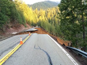
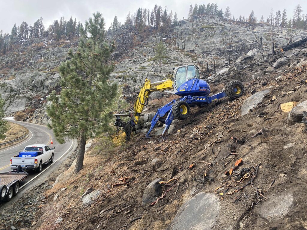
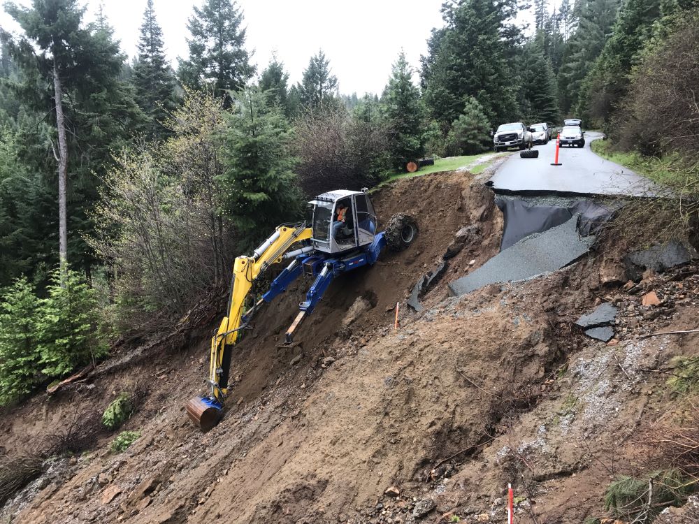
Landslides occur when masses of rock, earth, or debris move down a slope. Triggered by intense rainfall, rapid snowmelt, seismic activity, or construction activities, landslides can block highways, damage buildings, and sever utility lines. Slope failures vary in speed and volume but are always capable of causing significant infrastructure disruptions, especially in mountainous or hilly regions.
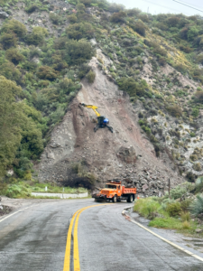
 Rockfalls
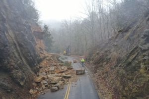
Rockfalls involve the sudden detachment of rock from cliffs or steep slopes. Highways, railways, and other infrastructure located near rock faces are especially vulnerable. These events are often triggered by freeze-thaw cycles, root growth, heavy precipitation, or seismic activity. Even small rockfalls can present serious hazards to passing vehicles and structures.
 Erosion and Scour
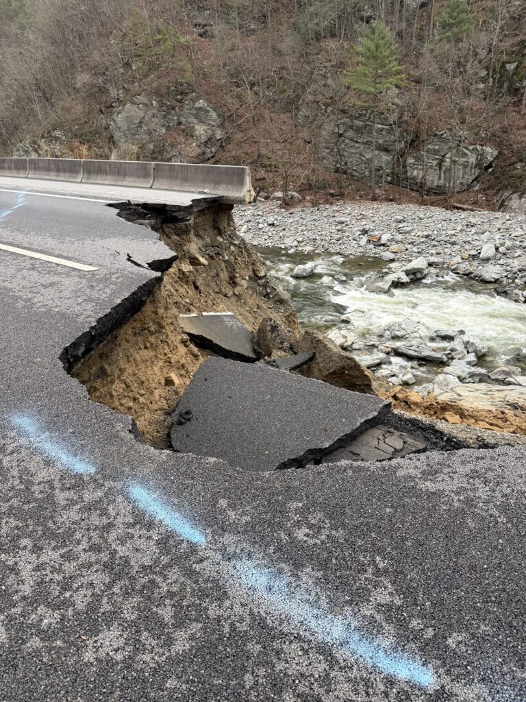
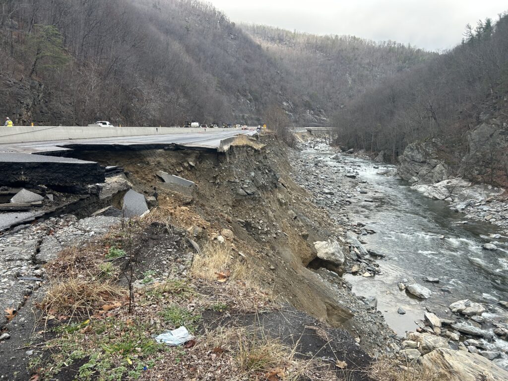
Erosion is the gradual removal of soil or rock by water, wind, or ice. Infrastructure near rivers or coastlines may be at risk of foundation exposure or slope instability due to erosion. Scour, a specific form of erosion, refers to the rapid removal of sediment from around bridge piers, abutments, or other submerged structures by swiftly moving water. Both processes can undermine foundations, reduce load-bearing capacity, and result in structural failure.


Flooding
Flooding is one of the most widespread and damaging natural hazards affecting infrastructure. It can occur due to heavy rainfall, snowmelt, storm surges, or dam failures. Floodwaters can inundate roadways, damage electrical systems, erode soil supporting bridges, and compromise the structural integrity of buildings and levees. Saturated soils also increase the likelihood of landslides.
 Seismic Activity
Earthquakes and ground shaking can destabilize slopes, fracture pipelines, collapse tunnels, and damage dams and foundations. Liquefaction—when saturated soil temporarily loses strength during seismic events—poses a significant threat to structures built on loose, water-saturated ground. Infrastructure located near fault zones must account for these risks through seismic-resistant design and retrofitting.
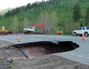
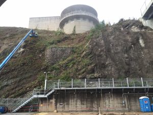
Subsidence and Sinkholes
Subsidence is the gradual settling or sinking of the earth’s surface, often caused by groundwater withdrawal, mining, or natural dissolution of underground rock layers. Sinkholes are sudden depressions that occur when underground voids collapse. Both hazards can severely damage roads, buildings, pipelines, and utility corridors, particularly in karst regions with soluble limestone bedrock.
The effects of geohazards on critical infrastructure can be catastrophic, both in direct damage and long-term service interruptions.
Highways, bridges, railroads, and airports are highly susceptible to slope failures, scour, and seismic impacts. A single landslide can block a major transportation corridor for days or weeks, increasing costs and complicating emergency access. Railways in mountainous terrain are often disrupted by rockfalls and embankment instability.
Electric transmission towers, substations, and gas pipelines frequently traverse rugged or remote areas. Geohazards such as landslides, flooding, and ground movement can down power lines or rupture pipelines, affecting regional power grids and fuel supplies. Energy providers must carefully monitor and protect these assets.
Water treatment plants, dams, levees, and underground utilities are vulnerable to flooding, erosion, and seismic events. Inundation can compromise water quality and interrupt service. Buried pipelines may crack or separate due to subsidence, leading to leaks and contamination.
Cell towers, fiber optic networks, and data centers depend on stable ground and accessibility. Slope failures and soil instability can disrupt service in remote regions, while flooding can damage critical relay equipment. These interruptions have wide-ranging effects, especially in emergencies.
The complexity of geohazards requires a multidisciplinary approach that integrates geotechnical engineering, hydrology, structural design, and advanced monitoring technologies.
Geotechnical Site Assessments - Understanding site-specific soil and rock conditions is a critical first step. Subsurface investigations, slope stability analysis, and hydrological modeling help engineers identify potential hazards and design appropriate mitigation systems.
Slope Stabilization and Rockfall Protection - To address unstable slopes, engineers often employ soil nails, anchors, retaining walls, or mechanically stabilized earth (MSE) systems. Rockfall-prone areas may require draped mesh, catch fences, or attenuator barriers to intercept debris before it reaches infrastructure.
Foundation Reinforcement - In areas with weak or variable soils, deep foundation systems such as micropiles or helical anchors provide added stability. These solutions are especially valuable for retrofitting aging infrastructure or building on challenging terrain.
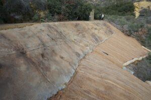
Erosion and Scour Control - Measures to protect against erosion include the use of riprap, articulated concrete blocks, and vegetation-based solutions. Scour protection often involves modifying hydraulic flows and reinforcing bridge foundations with specially designed materials.
Real-Time Monitoring - Advances in geotechnical instrumentation allow for real-time tracking of ground movement, pore water pressures, and structural deformation. Remote sensing tools like LiDAR and UAV mapping enable rapid post-event assessments and ongoing risk evaluation.
Integrated Infrastructure Resilience Planning - Beyond isolated repairs, long-term geohazard mitigation requires incorporating resilience planning into infrastructure design and management. This includes:
Collaborative planning efforts with federal, state, and municipal agencies—as well as private asset owners—are vital to identifying regional vulnerabilities and prioritizing critical infrastructure improvements.
Community and Stakeholder Engagement - Effective geohazard mitigation doesn’t end with engineering. Public and stakeholder engagement plays a crucial role in ensuring that mitigation efforts are sustainable, equitable, and well-supported. Incorporating local knowledge, aligning infrastructure priorities with community needs, and promoting risk awareness can lead to more successful outcomes.
For example, public workshops and community-based hazard mapping initiatives help generate local support for major infrastructure projects. Transparent communication during mitigation efforts can also improve outcomes by minimizing project delays and building long-term trust.
By taking a holistic and collaborative approach, infrastructure operators can develop systems that not only withstand current geohazard risks but are also prepared for evolving environmental conditions.
The following scenarios illustrate practical applications of geohazard mitigation:
 Mountain Corridor Stabilization: A steep slope above a key highway in the Pacific Northwest showed signs of distress after prolonged rain. Engineers installed a combination of soil nails, shotcrete, and surface drains to prevent further movement and ensure long-term slope stability.
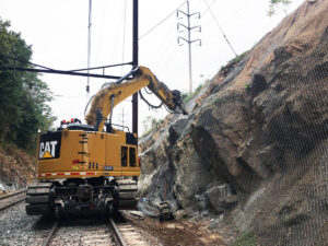 Rockfall Barriers Along Rail Line: In the Appalachian region, frequent rockfalls endangered a freight rail corridor. Hybrid rockfall barriers were deployed, allowing for controlled energy dissipation and minimal maintenance.
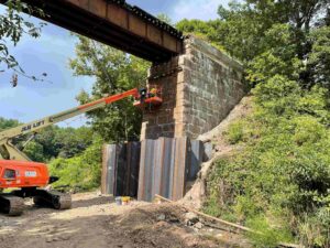
![]() Sinkhole Stabilization Beneath Utilities: A sinkhole opened near a municipal substation in central Florida. Engineers installed a micropile-supported foundation mat to transfer structural loads beyond the unstable subsurface, restoring integrity and preventing future settlement.
Sinkhole Stabilization Beneath Utilities: A sinkhole opened near a municipal substation in central Florida. Engineers installed a micropile-supported foundation mat to transfer structural loads beyond the unstable subsurface, restoring integrity and preventing future settlement.
Erosion Control for Riverbank Infrastructure: Heavy seasonal flooding eroded the banks of a river supporting a critical utility corridor. A combination of geotextile wraps, live staking, and articulated concrete blocks helped restore the slope while maintaining ecological function.
 Retrofitting Historic Structures in Seismic Zones: In the Pacific Southwest, a 100-year-old bridge was retrofitted using carbon fiber reinforcement and micropile foundations to reduce seismic vulnerability while preserving its historical character.
Community Resilience in Rural Alaska: An arctic community at risk of permafrost thaw and coastal erosion implemented a combination of thermosyphons (to stabilize frozen ground) and protective berms, showcasing a community-led approach to infrastructure adaptation.
Climate change is exacerbating geohazard risks. Increased precipitation intensity, rising sea levels, and more frequent freeze-thaw cycles all contribute to slope instability, erosion, and flooding. Infrastructure systems designed based on historical weather patterns must now contend with more extreme and unpredictable events.
Research from the U.S. Geological Survey and National Climate Assessment indicates that landslide-prone regions in the Pacific Northwest and Appalachians are likely to see increased slope movement, while thawing permafrost in the Arctic threatens the stability of roads, runways, and pipelines. Coastal regions face more frequent and intense flooding due to sea-level rise and storm surge.
Designing with climate resilience in mind means accounting for greater variability in rainfall, temperature, and hydrologic behavior. Engineering standards are evolving to reflect these changes, and geohazard mitigation strategies must remain adaptive and forward-looking. Resilient infrastructure not only considers the present but also integrates long-term forecasts into planning and material selection.
Geohazards are an unavoidable part of the natural world, but with careful planning and engineering, their impacts on critical infrastructure can be significantly reduced. Through geotechnical analysis, site-specific design, and the integration of innovative materials and technologies, infrastructure systems can be made safer and more resilient.
Whether addressing slope instability, mitigating rockfall risk, or reinforcing foundations against scour and subsidence, informed intervention is key. As infrastructure ages and environmental conditions evolve, proactive geohazard mitigation will remain essential to public safety and economic stability.
Decision-makers must prioritize risk-informed investment strategies, particularly in high-exposure areas such as transportation corridors, utility hubs, and coastal regions. Partnerships between government agencies, academia, and private industry will also be key to developing the next generation of resilient infrastructure.