Erosion control in Maine operates on two fronts simultaneously. Along the coast, the Maine Geological Survey documents average annual losses of a foot or more on some beaches and bluffs — with erosion rates up to 3 feet per year in the most vulnerable areas. Sea level at Portland has risen approximately 0.6 feet over the last century and is projected to accelerate. Maine's glacially deposited bluff and beach sediments are geologically young and unconsolidated — they require very little wave energy to erode.
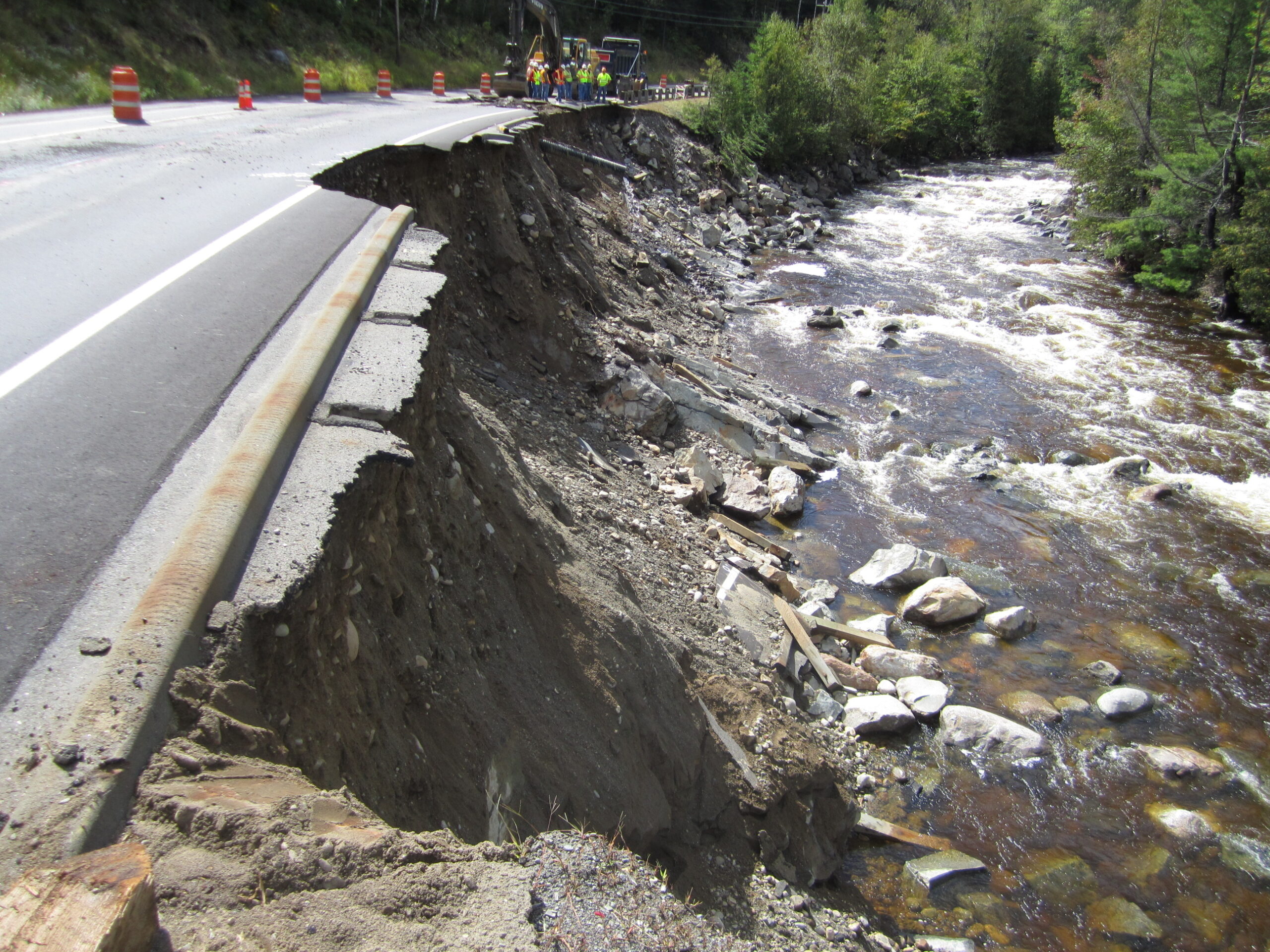
Inland, Maine's rivers present an equally active erosion challenge. The December 2023 storm produced nearly 100 MaineDOT road closures concentrated along the Sandy, Swift, Carrabassett, Kennebec, and Androscoggin Rivers and their tributaries. Bridges were closed statewide due to high, fast-moving water, and road embankments along river corridors suffered significant scour and undermining. These aren't isolated events — Maine's river systems regularly produce damaging high-water events that erode embankments, undercut bridge abutments, and compromise road shoulder stability.
MaineDOT and Maine's municipalities, utilities, and infrastructure owners face erosion challenges across both environments. GeoStabilization International designs and builds erosion control solutions for all three — coastal shorelines, streambanks, and road embankments — under a single design-build contract.
Revetment armor resists wave energy, storm surge, tidal scour, and river current erosion. Effective erosion control in Maine requires armor sized for the specific conditions at your site — Maine's tidal range is among the highest on the US East Coast, and river flow velocities during high-water events vary significantly between Maine's major river corridors.
GeoStabilization International designs revetment systems calibrated to site-specific wave energy, current velocity, tidal range, substrate conditions, and storm exposure.
River corridor erosion control requires solutions that manage hydraulic forces, not just surface protection. Where Maine's river banks have been undercut by flow, GeoStabilization International installs streambank stabilization systems that address scour at the toe while stabilizing the bank face — protecting road embankments and infrastructure from continued lateral erosion.
The Maine Geological Survey and Casco Bay Estuary Partnership have documented growing interest in living shoreline approaches for Maine's coastal bluff and marsh-edge environments — solutions that control erosion while maintaining the natural shoreline character and satisfying Maine DEP permit requirements. Bioengineered erosion control strengthens over time as vegetation establishes, reducing long-term maintenance compared to hard armor alone.
Where river scour or coastal erosion has undermined road embankments, slope faces, or infrastructure foundations, GeoStabilization International installs anchoring systems — soil nails, ground anchors, and micropile underpinning — that mechanically stabilize the eroded embankment and transfer loads to stable strata below the active erosion zone.

Storm surge in winter, snowmelt in spring, high river flows after summer rains — erosion control in Maine is a year-round challenge on both coasts and river corridors. GeoStabilization International's engineers are ready to assess your site and deliver a solution built for Maine's conditions. Request an erosion assessment to get started.